Participatory 3D Modelling of the Bi Doup-Nui Ba (BD-NB) National Park, Vietnam
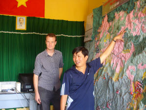
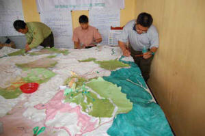
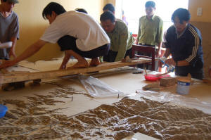
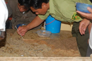
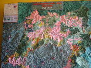 This 1:15,000 horizontal scale (1.5 X vertical exaggeration) Participatory 3D Model (P3DM) of the Bi Doup-Nui Ba (BD-NB) Nature Reserve, Vietnam was completed during the period July-August 2008. It has been produced by local stakeholders in the framework of the Project “Co-management of Forests and Wildlife in the Bi Doup-Nui Ba (BD-NB) Nature Reserve”, Vietnam (July 2007 to October 2010)
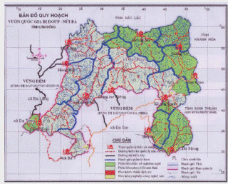
The model covers a total area of 1800 sq km was built by representatives from selected communes and the Nature Reserve management board with assistance provided by project staff. The initiative is part of a broader intervention having the objective to conserve threatened biodiversity in the Reserve.
 The process of building the model was used to identify areas of conflict and between the BD-NB National Park and the communes. Generally these were areas of coffee plantation established within the protected area. According to project implementers the process resulted in higher awareness of boundary issues and overlapping interests between the communes and the protected area. Project implementers acknowledge that higher awareness may be temporary and that there is the need for collaboratively delineate revised boundaries.
Bi Doup-Nui Ba (BD-NB) National Park was decreed in 1986. It is one of the larger protected areas in Vietnam, encompassing 72,573 ha. It is mountainous and forms a vital watershed to three distinct water catchments. It falls within a landscape which has been independently identified by leading national and international scientists as one of the highest conservation priorities within the Greater Annamites ecoregion (source, IIED).
 The human population in the buffer zone surrounding BD-NB is growing with concomitant pressure on land and natural resources both inside and adjacent to the protected area. In addition, the integrity and the bio-diversity of BD-NB is threatened by infra-structure and potentially uncontrolled tourism development. The Bi Doup-Nui Ba Management Board identified that encroachment into the Park was an important threat and was in part a failure of the collaboration between the Park Management Board and the ethnic communities in the buffer zone.
Through IIED and WWF-GMS, the project has taken steps to develop and implement co-management approaches to work with communities that succeed in providing incentives for sustainable land use both in the buffer zone and the protected area (source, IIED).
The project has worked with local communes and the park management board to develop and implement co-management practices that enabled local communities to sustainably utilise natural resources within the park whilst protecting biodiversity.
The project had the following components:
- Developing and implementing legal frameworks for community management
- Building capacity of buffer zone villagers to negotiate, monitor and benefit from co-management agreements
- Establishing a core protection zone, surrounding land use boundaries and community enforcement groups
- Carrying out an economic feasibility study and developing and implementing a community sustainable financing plan
- Training/empowering communities to monitor their natural resources and manage access to resources and the core national park area
- Reviewing and communicating lessons learned
Citation: “Participatory 3D Modeling has become a standard tool to assist with challenging issues around that involve contested boundaries and land use planning. The methodology has been used to great effect by IIED and WWF in the Mondulkiri Wilderness Area in Cambodia” (Source: Darwin Initiative Annual Report)

Follow us!