Participatory 3D Model of the Elephant Conservation Area in Que Son District, Vietnam
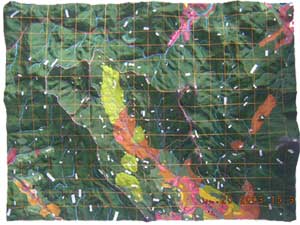
 This 1:15,000-scale (vertical 1:7,500) 3D model of the Que Son District, Quang Nam Province, Vietnam was completed in September 2003 in the framework of the USAID/WWF US funded (2001-2003) MOSAIC (Management of Strategic Areas for Integrated Conservation) project. Project implementation agencies included WWF Indochina Programme, the Center for Environment, Tourism and Development and the Department of Forest Protection of Quang Nam Province
The model covers a total land area of 675 km2 (30 km x 22.5 km). Depicted data reflect the cognitive maps of 80 local people most pertaining to ethnic groups, 30 school children local teachers of a primary and secondary school.
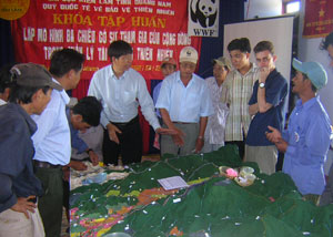
 The model has been used for collaborative research and planning purposes with the objective of establishing an elephant conservation area in full consultation with local communities. In this context the model has been used for land use planning and for establishing forest protection groups in villages.
Read more:
Richard M. Perron, 2001. Human-Elephant Conflicts in Tien Phuoc & Tra My Districts Quang Nam Province, Vietnam, IUCN-CBSG
Conservation goes 3D, Interview with James Hardcastle, WWF. Posted on 16 January 2004
Follow us!