Participatory 3D Modelling for Climate Change Adaptation and Disaster Risk Reduction in Divinubo Island, Philippines
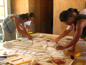
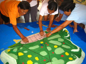
This 1:400-scale model (10 x vertical exaggeration) of the the Municipality of Borongan, Island of Divinubo, Eastern Samar, Philippines was completed in Yr 2007.
This 3D model has been produced in the context of the Samar Coastal Research for Environment and Development (e-SACRED) project and specifically within the framework of a Community-Based Disaster Risk Reduction (CBDRR) initiative proposed by scientists after identification by the local government of a gap in the disaster risk reduction framework.
The model features the collective knowledge local residents and representatives from the Divinubo People’s Organization, the City Government of Borongan, and the University of the Philippines Diliman.
The 3D model was produced on 27-31 August, 2007 and subsequently used for vulnerability mapping activities. Results included the following: Assessment of hazard, vulnerabilities and capacities, establishment of a CBDRR plan and methodological learning.
The 3D model has been produced in the framework of the Samar Coastal Research for Environment and Development (e-SACRED) project with financial support provided by the French Ministry of Foreign Affairs. The event has been hosted by the City Government of Borongan, Eastern Samar
Recommended readings:
Gaillard JC and Maceda E.A, 2009, Participatory three dimensional mapping for disaster risk reduction, PLA 60, 109-118, IIED, UK
Maceda E. et al. Experimental Use of Participatory 3-Dimensional Models In Island Community-Based Disaster Risk Management. Shima, The International Journal of Research into Island Cultures; Volume 3 Number 1 2009
Gaillard, JC., Cadag, Jke Rom D., Lingad, Leigh G., Maceda, Emmanuel A., and Viado, Ryan Christopher P. 2009. Participatory 3-Dimensional Mapping (P3DM) for Disaster Risk Reduction. Presentation delivered at the conference on Disaster Risk Reduction for Natural Hazards: Putting Research into Practice, 4-6 November 2009
Additional information on the case is found here.
Location map:
Follow us!