Participatory 3D Models of the Upper Nan Watershed Management Project, Nan Province, Thailand
 The 3D models shown below are some of the many which were produced in the framework of the Upper Nan Watershed Management Project (UNWMP) (1997 – 2003) in Nan Province, Thailand. Funded by DANCED, the project has been implemented by the Thai Royal Forestry Department.
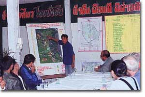
This 1:12,500 scale 3D model, represents the Nam Yao Watershed and includes seven villages (approx. 200 sq. km) located in the Upper Nan Watershed. The model, manufactured in year 1999, has been used for planning community-fire management.
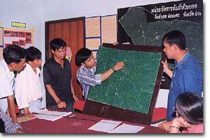
This second 3D model manufactured in 1997 at a 1:10,000 scale, represents one village located within the Upper Nan Watershed. It has been used for land use planning and village boundaries.
Recommended reading:
Hoare P, Maneeratana B., Songwadhana W., Suwanmanee A. and Sricharoen Y. 2002. Relief Models, a Multipurpose Tool for Improved Natural Resource Management The Experience of the Upper Nan Watershed Management Project in Thailand. ASEAN Biodiversity, Vol. 2 No. 1, 11-16. ASEAN Centre for Biodiversity Conservation (ARCBC), Los Baños, Philippines. 6 pages
Follow us!