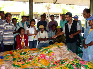
Participatory 3D Modelling for Climate Change Adaptation and Disaster Risk Reduction in Raumoco, East Timor
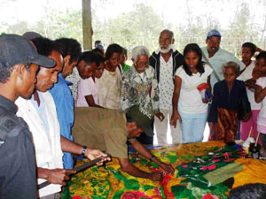
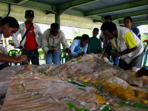 This 1:8,000-scale model (2 x vertical exaggeration) of the the Raumoco Watershed, Lautem District, Sub-Districts of Luro and Muro, East Timor was completed in year 2007.
This model was produced in the context of the Coordinated Actions for Disaster Risk Reduction Empowerment (CADRE) project and specifically within the framework of the Raumoco Watershed for the community-based disaster risk reduction program.
The model features the collective knowledge of representatives of the Sucos (villages) Afabubo, Baricafa, Kotamuto, Lakawa, Luro and Wairoke in Luro Sub-District and the Sucos Daudere, Maina II, and Serelau in Muro Sub-District. The 3D model was produced on 6-17 August, 2007 and subsequently used for vulnerability mapping activities on 18-31 October, 2007.
The Project objective was to contribute to reduced vulnerability of communities and populations from flooding and drought through the development of sustainable, replicable and coordinated preparedness and mitigation actions at the local, national and regional levels. More specifically the project purpose was Improved disaster risk reduction capacities and strategies of poor and vulnerable women, men and children,’target communities and other key stakeholders of the Raumoco watershed. The objective was meant to be achieved via a series of activities of which the production of the 3D model was the first one.
CADRE aims to contribute in reducing vulnerabilities of communities from disasters by floods and droughts through development of sustainable, replicable, and coordinated preparedness and mitigation actions at the local and national levels. Specifically, it works on improving capacities and strategies of poor and vulnerable sectors and other key stakeholders for disaster risk reduction. P3DM is introduced for partner communities and other key stakeholders to understand better the physical and biological characteristics of their watershed and how hazards impact their livelihoods and living conditions. The output 3D map will be used in planning, monitoring, and evaluating disaster risk reduction interventions.
Partner agencies & focal points included PROSPEK NGO, Fraterna NGO, Sub-Districts of Luro and Muro, District of Lautem/Lautem District, Disaster Management Committee, National Disaster Management Office (NDMO)/Civil Protection, Directorate of the Ministry of Interior.
Recommended readings:
Purzuelo M.B., Azares G. and Merza MA. 2007. Report of the Raumoco Watershed Vulnerability Mapping in East Timor, October 18-31, 2007. Concern Worldwide & GF-WV; 25 pages
Purzuelo M.B., Azares G. and Merza MA. 2007. Skills Training on: Participatory 3-Dimensional Modeling (P3DM) Participatory Geographic Information System (PGIS) Raumoco Watershed Lautem District, East Timor. Concern Worldwide & GF-WV;41 pages
Location map:
Follow us!