 Participatory 3D Modelling in the context of the Thai-German Highland Development Programme, Thailand
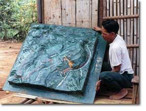
The Thai-German Highland Development Programme (TG-HDP), Chiang Mai, Thailand (1981-1998) has been the environment where the P3DM method has been systematically applied within a project context. 3D models were mainly done to represent single villages.
Below are two models:

Recommended readings:
Puginier O. 2002. “Participation” in a conflicting policy framework: Lessons learned from a Thai experience. ASEAN Biodiversity, Vol. 2 No. 1, 35-42. ASEAN Centre for Biodiversity Conservation (ARCBC), Los Baños, Philippines. 8 pages
Puginier O. 2002: Planning, Participation and Policy. Hilltribes overcoming the dichotomy between agriculture and forest preservation in Northern Thailand. [1.47 MB, 121 pages]
Puginier O. 2000. Can participatory land use planning at community level in the highlands of northern Thailand use Geographic Information Systems (GIS) as a communication tool ? Case Study 4. Land-Water Linkages in Rural Watersheds Electronic Workshop 18 September – 27 October 2000. FAO
Follow us!