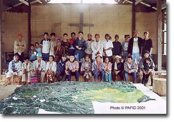
Participatory 3D Model of the AGMIHICU Ancestral Domain Claim
 The Agtulawon-Mintapod Higa-onon Cumadon (AGMIHICU) applied for a CADC in May 1995 under the Ancestral Domains Office at the DENR. The CADC was awarded in February 1998. The boundaries set down by the actual survey claim were far from what the community elders identified as the extent of their domain, and the size was greatly reduced. In response to this the communities sought assistance from the Philippine Association for Inter-Cultural Development (PAFID) to document their ancestral occupancy of a significantly larger territory.
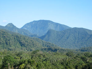 The ensuing 1:5,000 scale 3D model of the ancestral domain (10,054 ha) of the Higa-onon Peoples was completed over the period 2001-2004 in the Municipality of Impasug-ong Bukidnon, Philippines. The area represented on the model includes the forests of Mt. Kimangkil, rivers, waterfalls and sacred spaces. The model was constructed and populate by representatives from Sitios of Mintapod, Agtulawon, Kiudto, Amosig,Tug-onganon, Kabagtukan, Buntongon.
Based on accounts by the facilitating agency PAFID, the 3D modelling process helped the community determine the past, present and future land-use of their lands, and resolve boundary conflicts both within and outside the communities.
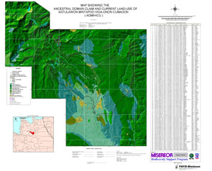
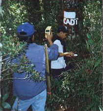
Maps produced as a result of the process were instrumental in the communities’ negotiations with the government and other entities. Maps equipped the community members with better knowledge of their land and served as a common language for addressing the conflicting views of different entities involved. Data gathered via GPS surveys enhanced the legitimacy of the Higa-onon claim and allowed members of the communities to become the leading actual actors in the process. The survey gave a sense of ownership to the community.
Recommended reading:
Abeto R., Calilung Z., Talubo J.P. and Cumatang B. 2004. Community Mapping in the Philippines: A Case Study on the Ancestral Domain Claim of the Higa-onons in Impasug-ong, Bukidnon. PAFID
Text and images courtesy PAFID, Philippines
As the second largest island in the Philippine archipelago, Mindanao covers a third of the country’s land resources. It is home to a quarter of the nation’s indigenous or lumad peoples, who are rapidly losing their land and its natural resources to warlords and the island’s economic elite.
Activities were carries out in the context of a project known as “Mapping the ancestral domains of the indigenous peoples in Mindanao” and which was carried out by the Philippine Association for Intercultural Development (PAFID). Its objective was to set up to secure the land tenure rights of the indigenous communities over their ancestral domains. The passage of the IPRA Indigenous Peoples Rights Act (IPRA, Republic Act No. 8371) has provided the legal backbone to achieve this. Mapping and delineation of ancestral domains consisted in a highly participatory process, involving on-ground surveys utilizing both traditional methods and state-of-the-art technology such as the Global Positioning System (GPS). The involves also the manufacture of scaled 3D models of the ancestral domains by community members, enabling them to easily grasp the basic concepts of spatial, biophysical analysis in determining the current resource base and boundaries of their ancestral domain.
Follow us!