P3DM for self-determination and cultural survival among Tagbanwa Peoples in Coron Islands
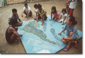
1:5,000 scale model of Coron Island, Palawan, Philippines (Yr 1998) manufactured by Tagbanwa people to support their claim for ancestral domain rights. The domain includes terrestrial and marine components and covers a total area of 22,284 hectares. The model has been instrumental – among others – in gathering evidence supporting ownership of the ancestral domain (terrestrial and marine), delineating boundaries, filing the CADC and subsequent CADT applications and preparing the Ancestral Domain Management Plan required by law.
Method: PGIS including P3DM, GPS and GIS
Recommended readings:
Kail Zingapan and Dave De Vera. 1999. Mapping the Ancestral Lands and Waters of the Calamian Tagbanwa of Coron, Northern Palawan, PAFID, 10 March 1999
Maurizio Farhan Ferrari and Dave de Vera. 2004. A Choice for Indigenous Communities in the Philippines. Human Rights Dialogue 2.11 (Spring 2004): Environmental Rights. Carnegie Council on Ethics and International Affairs
_______ 2001. Mapping the Ancestral Lands and Waters . Saragpunta Foundation and PAFID, Indigenous Perspectives, Volume 4, No. 2, December 2001
Model and derived map produced by Tagbanwa People in the Philippines with the assistance of the Philippine Association for Inter-Cultural Development (PAFID).
Follow us!