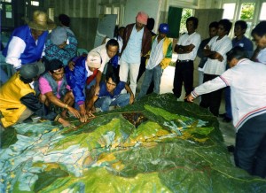
The use of Participatory 3D Modelling in managing conflicts
Bridging Communication Barriers By Offering a Shared Perspective and Visual Language
 Terrain elevation models virtual and physical have been successfully used in the context of conflict management. Specifically the use of participatory 3D models (P3DM) integrated with Global Positioning Systems (GPS) and Geographic Information Systems (GIS) has been successfully adopted in the Philippines by the Office of the Presidential Advisor on the Peace Process (OPAPP) to address inter-tribal territorial disputes. By creating shared vantage points and offering a common visual vocabulary, 3D models and derived maps are instrumental in bridging communication barriers, facilitating dialogue and limiting subjective interpretations, thus setting the basis for fruitful negotiations.
Different opinions are frequently based on different perspectives and the quality of the media used to communicate. When a process is geared towards addressing conflicts bound to the territory, appropriate communication channels are essential to grant all parties equal access to information in order to develop a common understanding of the issues at stake. Case in point is the so-called bird’s eye view offered by a scaled relief model through which a viewer acquires a holistic view of the landscape wherein landmarks and salient features are equally visible to everyone. In addition when language barriers represent a constraint, information exchange best occurs via visual communication means based on colors, shape and texture, like in a 3D model.
Documented cases:
Municipality of Balbalan, Kalinga, Philippines
Municipality of Lagawe, Ifugao Province, Philippines
Recommended readings:
Rambaldi G., Bugna S., Tiangco A. and de Vera D. 2002 Bringing the Vertical Dimension to the Negotiating Table. Preliminary Assessment of a Conflict Resolution Case in the Philippines. ASEAN Biodiversity, Vol. 2 No. 1, 17-26. ASEAN Centre for Biodiversity Conservation (ARCBC), Los Baños, Philippines
Srimongkontip, S. .2000. Building the capacity of watershed networks to resolve natural resource conflicts: Field experiences from the CARE Thailand Project. Asia-Pacific Community Forestry Newsletter, vol. 13:2
Wood B. W. 2000. GIS as a Tool for Territorial Negotiations. IBRU Boundary and Security Bulletin. Vol. 8 No. 3:72-78
Johnson, R. 1999. Negotiating the Dayton Peace Accords through Digital Maps. United States Institute of Peace (USIP) Virtual Diplomacy Report, 25 February 1999
Miguel Chacon. 2003. Principles of PPGIS for Land Conflict Resolution in Guatemala. Geography Department, UCGIS Summer Assembly 2003
Stauffacher D., Drake W., Currion P., Steinberger J. 2005. Information and Communication Technology for Peace: The role of ICT in preventing, responding to and recovering from conflict, United Nations, ICT Task Force, 101 pages
Kyem, P.A.K. 2004. On Intractable Conflicts Participatory GIS Applications: the Search for Consensus Amidst Competing Claims and Institutional Demands. Annals of the Association of American Geographers 94(1), 37-57
Carsten Keßler, Marion Wilde, Martin Raubal. 2005. Using Sdi-Based Public Participation for Conflict Resolution. Institute for Geoinformatics, University of Münster, Germany
Jennifer L. Jones. 2005. Transboundary Conservation in Southern Africa: Exploring conflict between local resource access and conservation; Centre for Environmental Studies University of Pretoria South Africa
Follow us!