Participatory 3D Modelling for asserting ancestral rights of the Sengwer Peoples in the Cherangani Hills, Kenya
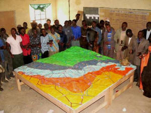
 This 1:10,000 scale (2 x vertical exaggeration) Participatory 3D Model of Cherangani Hills was completed in August 2007 in Trans Nzoia, Marakwet and West Pokot Districts of Rift Valley Province, Kenya. This 3D model covering a total area of 576 km2 has been the second Participatory 3D Model made in Africa. The exercise took place thanks to the financial support provided by the Rainforest Foundation UK, and the coordinated effort made by the Sengwer Peoples, ERMIS-Africa, Shalin Ry and the Indigenous Peoples of Africa Coordinating Committee (IPACC).
A total of 65 representatives from 13 sub-tribes attended the training. These included the following: Kaplema, Kamengetiony, Kipsirat, Kapteeteke, Kapsormwei, Kimarich, Kaasango, Kaptapkitiny, Kapkutung, Kapchongwony, Kaptokom, Kapumpo and Kapchepar.
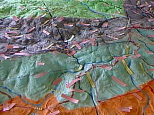
Elders populated the model with their memories and reconstructed the present landscape.
Sengwer is an indigenous group of the Nilotic descent. They speak Sengwer language which is closer to that of Sabaot and Keiyo communities. They live on hunting, gathering and a bit of farming and are distributed within their ancestral boundaries into three administrative districts of the Rift Valley province in Kenya: Trans Nzoia, Marakwet and West Pokot.
The Sengwer mapping has been a follow-up to the highly successful mapping of the Mau Forest Escarpment by the Ogiek people of Nessuit in 2006.
In 2007 the main outcome of the Sengwer mapping process revolved around negotiations with the KfW Development Bank as reported by Kiptum (2007):
- Recognition by KfW Development Bank, Kenya Government and Lake Victoria North Water Services Company that Cherangany Hills belongs to Sengwer Indigenous Peoples
- Recognition and respect that Kapolet is a river with spiritual and cultural attachment to Sengwer Indigenous peoples
- Acceptance by KfW Development Bank to fund community projects (Construction of a primary school, health centre, provision of water, electrification and road construction). Already Kshs 20 million has been set aside for the projects.
Nonetheless, the situation evolved for the worst and in 2013-2014 there have been forced evictions of indigenous communities from the area.
Recommended readings:
Kushner J., Langat A., Chavkin S. and Hudson M. 2015 Burned Out: World Bank Projects Leave Trail of Misery Around Globe. The Huffington Post. Consulted online on 10 January 2016.
International Bank for Reconstruction and Development. 2015. Progress Report to the Board of Executive Directors on the Implementation of Management’s Action Plan in Response to the Inspection Panel Investigation Report, Kenya, Natural Resource Management Project (IDA Credit No. 42770-KE). World Bank. 20 pages
______ 2014. World Bank accuses itself of failing to protect Kenya forest dwellers. The Guardian, 29 September 2014
Justin Kenrick. 2014. Governance regarding land and water distribution in Africa: The case of the Cherangany Hills, Kenya – State forest protection is forcing people from their lands, Forest Peoples Programme, November 2014, 14 pages
Muchemi J., Crawhall N., Pedone G. Koinante J. Kiptum Y. Kuria K. 2009. Kenya case study: Participatory 3-Dimensional Modelling; published in African Indigenous Peoples’ Workshop on effective use of Information Communication Technology (ICTs) in environmental advocacy, IPACC/CTA, Cape Town, South Africa.
Kiptum Y. and Odhiambo C, 2007. Safeguarding Sengwer Territory, Land, Culture & Natural Resources: Participatory 3-Dimensional Modelling of the Cherangany Hills, Kenya
_________ 2007. Proposed Kenya Water Supply and Sanitation Improvement Project (WaSSIP); Indigenous Peoples Planning Framework (IPPF), September 2007, Republic of Kenya, Ministry of Water and Irrigation.
Follow us!