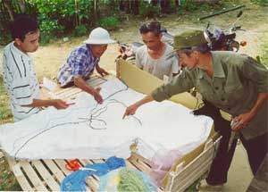
Participatory 3D Modelling used in the context of the Mountain Agrarian System Program, Bac Kan Province, Vietnam
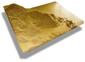
 1:3,000-scale 3D model of Phieng Lieng village, Cho Don District, Bac Kan Province, Vietnam . The model representing a total area of approx. 36 sq. km, has been used in 2001 for conducting a participatory diagnosis on spatial management of livestock systems.
Models produced in the framework of the The Mountain Agrarian System Program, Bac Kan Province, Vietnam. The Project is implemented by the Vietnam Agricultural Science Institute (VASI) in partnership with the International Rice Research Institute (IRRI, Philippines), Institut de Recherche pour le Développement (IRD, France), and Centre de Coopération Internationale en Recherche Agronomique pour le Développement (CIRAD, France).
 Method: Combination of digital models, role-plays, P3DM, spatial graphics in an integrated approach to local NRM.
Recommended readings:
Castella, J.C., T.T. Hieu and Eguienta Y. 2002. Combination of participatory landscape analysis and spatial graphic models as a common language between researchers and local stakeholders. SAM Paper Series 12. IRRI-IRD. 17 pgs
Tran Trong Hieu, Castella J.C. Eguienta Y. 2002 Participatory 3-D Landscape Modeling: Towards a common spatial language among researchers and local stakeholders. In: PAOPA (eds.) Scaling-up Innovative Approaches in Agricultural Development. Agricultural Publishing House, Hanoi, Vietnam. p. 13. (French and Vietnamese versions)
Follow us!