Participatory 3D Model of Union Island, Saint Vincent and the Grenadines
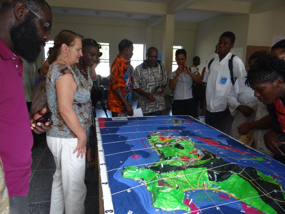 In 2013 the civil society organisation Sustainable Grenadines Inc. (SusGren), with support from The Nature Conservancy (TNC), the Technical Centre for Agricultural and Rural Cooperation ACP-EU (CTA), and The Grenada Fund for Conservation (GFC), organized a P3DM workshop on Union Island in the Grenadines. The exercise took place over the course of nine days, from February 28th to March 8th, 2013, in the Ashton Resource Centre, in the town of Ashton, Union Island and was attended by more than 100 residents. The workshop tookplace in the framework of the wider At the Water’s Edge project and was a result of 5 months of planning and preparation, including several preliminary meetings with stakeholders and community leaders, as well as two community mobililsation events in the towns of Ashton and Clifton. The District Office on Union Island has been a major partner in the project and represented the community of Union Island. Their head office the island’s Revenue Office building now houses the completed model. Stakeholders from the Caribbean Region attended the event as well. These included representatives from the Caribbean Climate Change Community Centre (5 C’s), Grenada Fund for Conservation, Grenada Red Cross, the Union FisherFolk Organisation (UIFFO) and others.
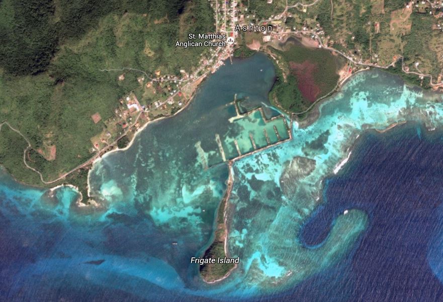 The objective of the P3DM exercise was to raise awareness on the need to restore the status of a vast lagoon which had been subject of a failed development which resulted in profoundly altering existing ecosystems. In fact, in 1994, a foreign developer obtained permission to build a 300-berth marina in the central section of the Ashton Lagoon. The plans included a causeway connecting Frigate Island to Union Island, a recreation centre on Frigate Island, a large condominium complex built on the outer reefs and a 50-acre golf course to be laid over the mangrove. What the plans failed to take into account was the destruction that would be caused to the land and seascapes. Before the building started, Ashton Lagoon had been the last remaining pristine lagoon in St. Vincent and the Grenadines. Located on the south coast of Union Island, the site was unique: it contained all the primary components of a lagoon and coral reef ecosystem, including a long stretch of outer reefs, a shallow, protected inner lagoon, abundant seagrass beds and the largest area of mangrove forest in the country. All four species of mangrove present in the region were found here until the construction vehicles moved in to start tearing them down. Unfortunately the marina complex was never finished. In mid-1995, the construction company declared bankruptcy and the project was abandoned. But the damage already done was incalculable. During construction, the lagoon was dredged and a road was built around the mangrove. A causeway built between Union Island and Frigate Island prevented water from circulating into the western half of the bay and the remaining water became stagnant and turbid. The seagrass beds, lobster, conch and many fish disappeared and corals died or became overgrown with algae. The restricted flow of seawater caused the mangroves to become severely stunted, and the salt ponds almost dried out.
Since 2004 SusGren and BirdsCaribbean have been involved in a variety of initiatives to restore Ashton Lagoon. These have included building skills and expertise in avian ecology among local residents and participatory planning and sustainable use of resources in the lagoon. SusGren succeeded in attracting funding from various international donors for restoration of the lagoon area. But the NGO came up against a major hurdle. Without official government approval for works to begin in the state-owned area, nothing could be done. After waiting for several years for the impasse to be resolved, the donors lost interest and withdrew their promises of funding. The situation could have remained unchanged if it had not been for a decision to build a P3DM of Union Island, plotting the extent of the damage done to the Ashton Lagoon area and the scope for regeneration. In February 2013, with support from CTA, TNC and GFC, SusGren facilitated the P3DM exercise documented below. “The model served to help the government visualise what is possible and promoted the vision with the people,” said Orisha Joseph, Programme Administration Officer at SusGren. “We used the momentum gained to contribute to driving the process forward.”
Victory finally came on January 7, 2015, when the Government of St. Vincent and the Grenadines gave approval for restoration work to begin in Ashton Lagoon. The decision was issued through Cabinet note ARTFF, a document that now holds the key to SusGren’s dogged campaign.
Based on an impact assessment conducted by CTA in 2015 the Union Island model made a significant contribution to plans to restore the Ashton Lagoon, as the model building exercise catalysed previously stalled efforts to gain official approval for commencement of restoration works. In November 2015 the Ashton Lagoon Restoration Project was officially launched.
Related video documentation
Local voices in climate change adaptation – Union Island, Caribbean – Trailer
Beneath the Surface ~ Mapping Union Island ~ A P3DM exercise, 2013
Sous La Surface ~ Cartographie de l’île d’Union ~ un exercice MP3D en 2013
Debajo De La Superficie ~ Cartografía de isla de la Unión ~ un ejercicio MP3D, 2013
Abaixo Da Superfície ~ Mapeamento ilha União ~ um exercício MP3D de 2013
Recommended readings:
DeGraff, Alison K., and Bheshem Ramlal. 2015. Participatory Mapping: Caribbean Small Island Developing States. In Forum on the Future of the Caribbean. St. Augustine, Trinidad: University of the West Indies, Trinidad & Tobago Ministry of Foreign Affairs, and the United Nations.
Follow us!