Participatory 3D Modelling with Ogiek Peoples in the Mau Complex, Kenya
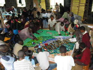
 This 1:10,000 scale (1.5 x vertical exaggeration) 3D model of part of the Mau Complex covers a total land area of 52,800 ha or 528 km2 and includes parts of the Nakuru and Narok Districts in Kenya.
This is the 1st Participatory 3D Model ever done in Africa.
It was completed in August 2006. The exercise has been made possible by the coordinated effort made by the Ogiek Peoples, ERMIS-Africa, the Technical Centre for Agricultural and Rural Cooperation (CTA), the Indigenous Peoples of Africa Coordinating Committee (IPACC), the Gaia Foundation-UK and the Nessuit Primary School.
 The exercise – which has been a step in a long lasting process initiated by the Ogiek Peoples to regain their cultural identity and lost ancestral territories (see case) – has stimulated community cohesion, surfaced lost memories on the environment and traditional ways of living as hunter-gatherers, facilitated inter-generational knowledge exchange and raised awareness on the critical status of the entire Mau Complex in terms of depleted forest cover and affected watershed functions. The elders concluded that they have now a more holistic understanding of their social, cultural and bio-physical environments. They will confer among themselves to define the best way forward in terms of improving the safeguarding of their traditional knowledge, the sustainable management of natural resources and advocacy actions aimed at regaining recognitions of their ancestral rights.
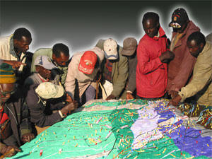
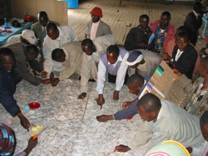
Depicted data reflect the mental maps of approximately 120 Ogiek Peoples from the 21 clans. Elders populated the model with their memories dating back to 1925 and reconstructed the landscape as it was at that time. The model displayed 64 data layers including different types of areas, points and lines. The blank model has been constructed by 30 students and 5 teachers from the Nessuit School and with the assistance of a total of 12 facilitators and trainees. In 2007 the model was expanded to include additional 290 km2 and specifically portions of the Njoro Watershed.
The Ogiek were involved in a series of P3DM exercises (e.g. Mount Elgon) all related to their quest for asserting their traditional rights on their ancestral lands.
Recommended readings:
Giacomo Rambaldi, Julius Muchemi, Nigel Crawhall and Laura Monaci. 2007. Through the Eyes of Hunter-gatherers: Participatory 3D Modelling among Ogiek Indigenous Peoples in Kenya. Information Development, Vol. 23, No. 2-3, 113-128
Giacomo Rambaldi, Julius Muchemi, Nigel Crawhall and Laura Monaci. 2007. À travers les yeux des chasseurs-cueilleurs : la modélisation participative en 3D chez les peuples autochtones Ogiek au Kenya. Information Development, Vol. 23, No. 2-3, Traduit et publié par le Centre Technique de Coopération Agricole et Rurale (CTA) avec la permission de « Information Development»
Giacomo Rambaldi, Julius Muchemi, Nigel Crawhall and Laura Monaci. 2007. A Través de los Ojos de los Cazadores-Recolectores: Modelado participativo tridimensional entre los pueblos indígenas Ogiek en Kenya. Information Development, Vol. 23, No. 2-3. Traducido y publicado por: Centro Técnico para la Cooperación Agricultural y Rural ACP-EU (CTA), 2010. Con permiso de: Information Development
Muchemi J. and Rambaldi G. 2007. Participatory 3-Dimensional Modelling and Mapping In Kenya. Safeguarding Territories, Land, Culture and Natural Resources in Africa. ERMIS-Africa, CTA, IPACC and Gaia Foundation. Vol. 1, 66 pages
Nkako HSC F., Lambrechts C., Gachanja M., Woodley B. 2005. Maasai Mau Forest Status Report 2005, Ewaso Ngiro South Development Authority, Kenya
Mau Complex Under Siege: Continuous destruction of Kenya’s largest forest UNEP, 2005
Ogiek elders offer conservation skills, Daily Nation, 28 July 2009
_______ 2012. Chepkitale Ogiek community document their customary bylaws for the first time in order to ensure the continued conservation of their ancestral lands and natural resources. Forest Peoples Programme
Video documentation:
The Voice of the Ogiek
In 2006 a little known ethnic group – called the Ogiek – created a three-dimensional map of their ancestral land in Kenya. In the past members of this indigenous community were regarded as second class citizen. Today, their story has gained international recognition. The Kenyan government is increasingly listening to their voice and including them in a dialogue over the future of their community and of the Mau Forest.
This is the story of how the Ogiek found their voice …
Follow us!