Participatory 3D Modelling for Climate Change Adaptation and Disaster Risk Reduction in Mangin, Dagupan, Philippines
CNRS, Universite´ de Grenoble, Grenoble, France
CNRS, Universite´ de Grenoble, Grenoble, France
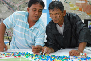
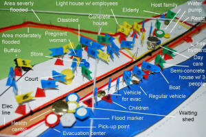
This 1:670-scale model (no vertical exaggeration) of Barangay Mangin City of Dagupan , Pangasinan Province, Philippines was completed over the period February – July 2009.
The model was produced in the context of the Program for Hydro-Meteorological Disaster Mitigation in Secondary Cities in Asia (PROMISE) specifically within the framework of a Community-Based Disaster Risk Reduction (CBDRR) initiative. The project was initiated by a local NGO as part of a larger CBDRR initiative.
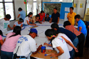
The model features the collective knowledge local residents and representatives from the Barangay, the Disaster Coordinating Council, City Government of Dagupan, Center for Disaster Preparedness, and the University of the Philippines Diliman. Funding has been provided by USAID and the Asian Disaster Preparedness Center.
CNRS, Universite´ de Grenoble, Grenoble, France
CNRS, Universite´ de Grenoble, Grenoble, France
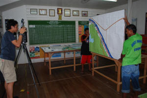
The 3D model was produced on 4 February 2009 and on 17-18 July 2009 and subsequently used for vulnerability mapping activities. Results includes the following: Spatial assessment of hazard, vulnerabilities and capacities, reinforcement of a CBDRR plan, and methodological learning.
Recommended readings:
Gaillard JC and Maceda E.A, 2009, Participatory three dimensional mapping for disaster risk reduction, PLA 60, 109-118, IIED, UK
Maceda E. et al. Experimental Use of Participatory 3-Dimensional Models In Island Community-Based Disaster Risk Management. Shima, The International Journal of Research into Island Cultures; Volume 3 Number 1 2009
Gaillard, JC., Cadag, Jke Rom D., Lingad, Leigh G., Maceda, Emmanuel A., and Viado, Ryan Christopher P. 2009. Participatory 3-Dimensional Mapping (P3DM) for Disaster Risk Reduction. Presentation delivered at the conference on Disaster Risk Reduction for Natural Hazards: Putting Research into Practice, 4-6 November 2009
Lorna P. Victoria. 2009. Combining Indigenous and Scientific Knowledge in the Dagupan City Flood Warning System; Good Practices and Lessons Learned from Experiences in the Asia-Pacific Region Indigenous Knowledge for Disaster Risk Reduction; pg 52-54
______ 2007, Cooperation between Local Authority and Communities Reducing Flood Disaster Risk in Dagupan City, Philippines, Safer Cities 16, PROMISE
Additional information on the case is found here.
Location map:
Follow us!