Participatory 3D Modelling of Mount Malindang Range Natural Park, Misamis Occidental, Philippines
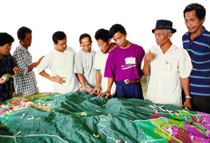
 This 1:10,000 scale model of Mt. Malindang Range Natural Park was completed in July 1999 in 3 weeks in the framework of the EU-funded National Integrated Protected Area Programme (NIPAP). The model covers a total area of 1,176 sq km and included Mount Malindang National park and its buffer zones in Misamis Occidental, Mindanao, Philippines.
The model included also five areas where indigenous Subanon communities were claiming ancestral domain rights.
 Mount Malindang and the whole Malindang Mountain Range alluring qualities come from its waterfalls, crater lake and dense virgin forests which host diverse and rare species of flora and fauna. On June 19, 1971, the area was proclaimed as Mount Malindang National Park by virtue of Republic Act 6266. Under the establishment of National Integrated Protected Areas System (NIPAS) in 1992, the park was reclassified and was renamed as Mount Malindang Range Natural Park on August 2, 2002 through Proclamation No. 228.
Additional references:
Rambaldi G., Mendoza M. and Ramirez F. 2000. Adding the fourth dimension to Participatory 3-D Modelling. PLA Notes 39: 19-24, IIED, London, UK
Dingal R. Balcita J. 2000. Profile of Mount Malindang National Park (MMNP). Suhay. October 2000 – January 2001, pages 30-31, National Integrated Protected Area Programme (NIPAP), Quezon City, Philippines
Follow us!