Participatory 3D Modelling in the Upper Nan Watershed, Nan Province, Thailand for watershed rehabilitation
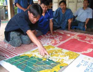
 1:12,500-scale model of of one village located within the Upper Nan Watershed, Nan Province, Thailand.
The rapid deforestation in Nan prompted the Thai Royal Forestry Department (RFD) to set up the Upper NAN Watershed Management Project. In 1996, this Project received support for capacity development in environment managcment from the government of Denmark, through DANCED. The project comprised six Watershed Management Units and 4 villages of different ethnic groups including, Muang, Hmong, and H’tin. The key to the rehabilitation process in the Nan Watershed has been the use of participatory land use planning (PLUP) at the micro-watershed level, as well as the provision of supplemental revolving funds for irrigated paddy crops and agro·forestry. PLUP including P3DM has been so effective that it is now considered to be the ‘traditional’ watershed management process in Thailand (Ewers 1998).
The model was/is used for collaborative watershed management purposes. It was manufactured by the community in the framework of the Upper Nan Watershed Management Project (UNWMP), Nan Province, Thailand (1997 – 2003) and updated in 2001.
The Project has been implemented by the RDF with financial assistance from DANIDA.
Follow us!